Archive Record
Images
Metadata
Object ID |
L140.07 |
Title |
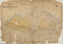
Atlas of the Borough of Richmond |
Object Name |
Map |
Scope & Content |
Elisha Robinson of E. Robinson and Co. was a prolific cartographer and publisher of atlases for localities across the United States, including many for New York City and its surrounding counties. Robinson produced two atlases of Staten Island: one in 1898 and one in 1907. The 1898 atlas, shown here, provides an important snapshot of Staten Island in year that the five boroughs consolidated to become the City of New York. The index page at the front of the atlas shows how Staten Island is divided into plates that provide detailed views of landowners, buildings, natural features, and infrastructure throughout the borough. |
Creator |
E. Robinson & Co. |
Collection |
Maps and Atlases |
Web Rights |
http://rightsstatements.org/vocab/InC-NC/1.0/ |
Catalog type |
Map |